Manta Point Komodo, formally Karang Makassar, is Komodo National Park’s premier manta-ray cleaning station. It sits in the central park waters between Komodo Island and Tatawa Besar at GPS 8.6136°S, 119.5120°E. Reef manta rays (Mobula alfredi) live here year-round, and both divers and snorkelers see them at depths of 6 to 18 metres.
Where to See Manta Rays in Komodo
Komodo National Park holds two distinct manta hotspots. Once you understand the difference between them, you can build a better itinerary. One sits in the central park and stays calm. The other lies in the south and runs wild. Both reward patience, and both are easier to reach on a liveaboard than on any day-trip boat out of Labuan Bajo.
Manta Point (Karang Makassar) — The Cleaning Station
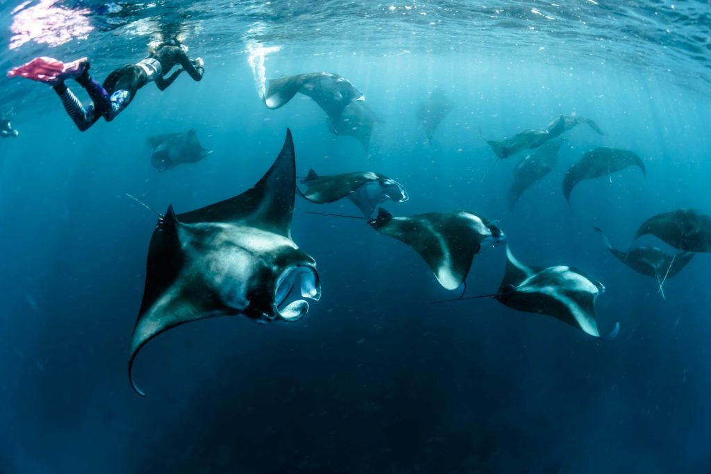
Karang Makassar has earned its informal title. Reef manta rays (Mobula alfredi) arrive here to be cleaned. They hover almost motionless above a stretch of coral shelf while small wrasse pick parasites from their gill plates and skin. At a handful of cleaning stations in the Indo-Pacific snorkellers can watch this behaviour from the surface, and Karang Makassar is one of them, so guests who do not dive can still join in.
The site works between 6 and 18 metres, with the densest manta activity from 8 to 15 metres. On a rising tide in peak season, guides from boats operating in these waters have counted up to 50 individual rays in one session. Currents run mild to strong and sometimes touch 4 knots, which makes this a drift site. You fin in, let the current carry you past the cleaning heads, and surface well clear of where you started. Water temperature holds between 25 and 29°C, averaging 27 to 28°C. Visibility shifts with the conditions. On calm days you see 15 to 20 metres in every direction. When a plankton bloom moves through, that drops to 10 metres, though denser plankton also feeds the rays and pulls more of them to the site.
The best window for manta sightings runs November through March, matching the wet season when nutrient-rich currents move across the central park. May and June also deliver, as surface conditions settle and visibility improves. The reef manta lives here all year rather than visiting on a season, so you stand a fair chance of an encounter even outside the peak months. It asks for more patience on the drift.
Manta Alley — The Southern Feeding Ground
Roughly 25 kilometres south, near the southern tip of Komodo Island, Manta Alley works in another way. Karang Makassar cleans the rays; this site feeds them. Cold, plankton-rich upwellings push through the southern passage and draw mantas into feeding posture, where they barrel-roll through the water column with their cephalic fins unfurled. December through March is the prime window, when the upwelling intensifies and the mantas arrive in numbers. The water runs cooler and sometimes drops below 24°C, and visibility often falls. You trade clear water for the sight of a dozen rays feeding in formation, which the calmer central site never offers. Many liveaboard itineraries string Karang Makassar and Manta Alley together across a four- or five-night cruise, so guests get both the cleaning-station hover and the open-water feed.
Manta Point Komodo Diving vs Snorkeling
The shallow profile of Karang Makassar gives snorkelling a real edge over scuba at a dive site, which is rare. With mantas active between 8 and 15 metres and visibility reaching 15 metres and more, a snorkeller at the surface looks straight down on the whole cleaning station. You see the mantas’ full wingspan, and reef mantas span 3 to 3.5 metres, in context rather than foreshortened by proximity. For groups travelling with non-divers, a partner who snorkels above while you dive below reports the same sightings you do.
Divers hold the advantage on the current side. When a 4-knot drift runs, the surface carries snorkellers along fast and they must stay alert. Divers at 10 to 12 metres sit below the chop, hold neutral buoyancy, and place themselves under the cleaning heads where the rays hover longest. Open Water-certified divers handle the site without trouble, since there are no mandatory negative entries or strong thermoclines. On certain tides the current stiffens, so you should know how to read a reef hook and manage a surface marker buoy. Your liveaboard dive guides brief you on conditions before every entry.
Gili Lawa: Sunrise Hike, Sunset Views & Dive Sites
Two small islands in the northern section of Komodo National Park, Gili Lawa Darat and Gili Lawa Laba (also called Gili Lawa Laut), pack land and sea activities into one anchorage. The Bajo sea nomads navigated these same northern channels for centuries, reading tidal shifts by the colour of the water and the direction of the swells. The same channels now carry luxury phinisi and charter yachts to one of the park’s most versatile overnight stops.
Gili Lawa Darat — The Viewpoint Hike
Gili Lawa Darat offers the more accessible of the two summits. Guides rate the trail easy to moderate: a dirt and savanna path that gains 120 to 180 metres of elevation in 15 to 30 minutes of steady walking. There are no formal steps. The path is loose, dry grass and compacted soil, so rubber-soled shoes serve you better than sandals. Boats leave the beach for the sunrise climb at 05:00 to 05:30. Your liveaboard’s tender drops you before first light, and the sky begins to blush over the eastern ridgeline as you crest the top.
The view rewards the early start. To the north, Crystal Rock and Castle Rock rise from still water. To the south, Komodo Island curves away in the morning haze. Sunset works here too, and many boats anchor for an early evening hike, which skips the pre-dawn logistics. One practical note: the park service has at times closed trails on Gili Lawa Darat after grass fires destabilised sections of the slope. Confirm trail status in your onboard ranger briefing before you commit to a dawn hike.
Gili Lawa Laba, the neighbouring island, runs a steeper, longer hike of 20 to 35 minutes with an elevation gain of 150 to 200 metres and more exposed sections near the summit ridge. The views match Darat’s, and the harder climb filters out casual hikers, so the top stays quieter even when both boats anchor in the bay together.
Gili Lawa Diving Sites
The waters around Gili Lawa sit where north Komodo’s strongest tidal channels converge, which is why they produce such marine life. Liveaboards anchored here reach Castle Rock and Crystal Rock in a short tender ride of 10 to 20 minutes, which makes it one of the most efficient anchorages in the park for combining several dives in one day. The reef around the base of Gili Lawa itself holds shallower dives in the 8 to 20-metre range, well suited to a check-dive or a gentle afternoon session after a harder morning at the northern seamounts.
Signature Dive Sites Near Manta Point & Gili Lawa
Batu Bolong — The Pinnacle of Komodo Diving
Batu Bolong is a single basalt pinnacle that breaks the surface of the Lintah Strait in the central-north park. The rock looks plain above water, a jagged black protrusion about three metres high. Below the waterline, the walls drop vertically past 90 metres, though recreational dive profiles stay between 5 and 30 metres where the reef concentrates. You dive the lee side, timed to a slack or small tidal exchange, tucked behind the current shadow that lets the fish life hold position.
Batu Bolong packs marine life as densely as any site in Indonesia. Napoleon wrasse the size of coffee tables patrol the mid-water. Bumphead parrotfish move in loose formations, their foreheads dented from ramming coral heads. Curtains of fusiliers and anthias cascade down the wall, broken by white-tip and black-tip reef sharks cruising the surge. Giant trevally ambush from the deeper water, turtles rest in crevices, and on a good day a reef manta drifts through from the next channel. Visibility runs 15 to 30 metres and temperature 24 to 29°C, depending on the season. April through November are the optimal months, and June, July and August hold the most consistent conditions and the clearest water.
Castle Rock — Advanced Drift Territory
Castle Rock is a submerged seamount in the northern passage, about 15 minutes by tender from Gili Lawa. The summit sits 4 to 5 metres below the surface at low water, and the productive dive zone spans 15 to 35 metres on the current-scoured flanks. This is an advanced site. Currents run horizontal at 1 to 3 knots with occasional upwellings, and most operators ask for Advanced Open Water certification plus a minimum of 50 to 60 logged dives before they brief guests in. The entry is often negative: you step off the tender into the current and descend at once, aiming for the sheltered side of the pinnacle before the flow carries you over the top.
That commitment pays off. White-tip reef sharks rest along the base in numbers. Schools of giant trevally orbit the seamount tip, holding against the current with almost no fin movement. Dogtooth tuna and wahoo appear in the blue behind them. On the wall, a wide soft-coral garden grows perpendicular to the flow, fed by the constant upwelling of nutrient-rich water. Visibility in the dry season, April to November, reaches 20 to 30 metres, and the water temperature holds at 27 to 29°C.
Crystal Rock — Where Currents Meet Colour
Crystal Rock, close to Castle Rock in the northern channel cluster, is a pinnacle that partly breaks the surface. You can see the rock from the tender, which helps with orientation. The working depth range is 5 to 30 metres. Currents here also run strong, with split flows that create eddies on the lee side, and divers use those eddies to hold position and watch the pelagic traffic. Eagle rays pass through often. You tell them from mantas by their pointed wings and long tails. Reef sharks circle at mid-water, and the hard coral coverage is dense because the constant current delivers nutrients to the polyps.
Visibility at Crystal Rock in the dry season peaks above 20 metres and tops 30 metres in May and June, when surface conditions stay calmest. Like Castle Rock, it suits April through November. Pairing both pinnacles in one day, a morning dive at Castle Rock on the incoming tide and an afternoon dive at Crystal Rock on the outgoing, is a standard programme for liveaboards anchored at Gili Lawa, and one of the finest dive days in the Indonesian archipelago.
Best Time and Conditions for Manta Point and Gili Lawa
You can dive Komodo National Park year-round, though the experience shifts between seasons. November through March brings the wet season: heavier rain and rougher surface seas in the open channels, but also the peak manta aggregations at Karang Makassar and Manta Alley. Water temperature sits at its warmest, 27 to 29°C, and plankton blooms drive the mantas’ feeding. On some days a bloom cuts visibility at Manta Point to 10 metres or less, and that is when 30 to 50 rays appear in the water column together.
April through November, and the dry core of June through August, is when the northern sites, Batu Bolong, Castle Rock and Crystal Rock, run at their most consistent. Visibility extends to 25 to 30 metres, surface swells stay minimal, and the manta sightings at Karang Makassar continue in smaller numbers. Water temperature dips, averaging 25 to 27°C. If you focus on the pinnacles and seamounts, choose this window. If you put mantas above everything else, book November to March.
The Manta Point and Taka Makassar Boat Tour
Several itineraries out of Labuan Bajo combine Manta Point with Taka Makassar, the isolated white sandbar atoll about 15 minutes east of Karang Makassar in the central park. You reach Taka Makassar only by boat. Its horseshoe reef offers strong snorkelling in 2 to 6 metres of water, with healthy staghorn coral and a dense population of small reef fish. The pairing works as a half-day loop: you spend the pre-noon hours at Manta Point on the incoming tide when manta activity peaks, then transit to Taka Makassar for a snorkelling session and lunch in the lagoon before you return to the liveaboard. Guests who do not dive get two of the park’s finest surface experiences in one excursion.
Plan Your Cruise Around Manta Point and Gili Lawa
At Komodo Luxury, we have curated liveaboard voyages through these waters since 2015, across more than 10,000 guests, every season, and every tier of vessel from classic phinisi to private luxury yacht. Guests rarely ask us which sites to visit. They ask which order makes sense. The answer turns on current patterns, your group’s diving experience, and whether you came for mantas or hard corals. Our concierge team works out that detail with you.
You might be an Advanced diver who wants Castle Rock and Crystal Rock on the same day, a snorkeller building an itinerary around the Gili Lawa sunrise hike and a morning drift at Karang Makassar, or a couple planning a private charter with the freedom to follow the mantas wherever the tide takes them. Reach out and we will build it for you.
Contact our team to plan your cruise:
Message us on WhatsApp — our team will recommend the ideal boat and itinerary for your dates.
Email us at sales@komodoluxury.com — our concierge team typically responds within a few hours.
Frequently Asked Questions
- Where can you see manta rays in Komodo?
- The two primary sites are Manta Point (Karang Makassar), a year-round cleaning station in central Komodo National Park, and Manta Alley near the southern tip of Komodo Island, which is most active December through March. Liveaboards reach both within one multi-night itinerary, so you see contrasting manta behaviours: cleaning at the central site and feeding in the south.
- Can you snorkel with mantas at Manta Point?
- Yes. Karang Makassar concentrates its manta action at 8 to 15 metres, which makes it one of the few places in Komodo where snorkelling over the cleaning station produces close encounters. Visibility runs 10 to 20 metres, so you see reef manta rays from the surface without dive gear on most days.
- When is manta season in Komodo?
- Reef mantas at Karang Makassar stay year-round. The peak aggregation season runs November through March, when plankton blooms draw the largest congregations of up to 50 individuals in a single session. May and June also deliver, combining good manta sightings with better visibility as surface conditions settle after the wet season.
- How hard is the Gili Lawa Darat sunrise hike?
- Guides rate the hike easy to moderate. The trail climbs 120 to 180 metres on a dirt and savanna path and takes 15 to 30 minutes at a comfortable pace. There are no formal steps. You leave the beach around 05:00 to 05:30 to reach the summit at dawn. Check with park rangers before you hike, since the trail closes at times after grass-fire damage.
- What are the best dive sites near Manta Point and Gili Lawa?
- The three signature sites are Batu Bolong (a central pinnacle known for sheer fish density, best April to November), Castle Rock (a northern seamount that requires Advanced Open Water certification, currents 1 to 3 knots), and Crystal Rock (a northern pinnacle with hard-coral coverage and regular eagle ray sightings). You can reach all three from a Gili Lawa anchorage.
- Are the currents strong at Manta Point?
- Currents at Karang Makassar range from mild to strong and reach up to 4 knots on a strong tidal exchange. The site usually runs as a drift: you enter upcurrent and let the flow carry you past the cleaning station. Open Water-certified divers manage it, and your liveaboard dive guide adjusts entry timing to the day’s tidal conditions.